|
Cranberry Creek Mound Group State Natural Area This 675-acre site preserves one of the largest and best-preserved mound complexes in the Upper Midwest. The site contains conical, linear, oval, and effigy mounds built by Woodland Indians. The southern cluster contains bear and panther mounds and a 50-foot-long bird effigy with a wingspan of 125 feet. After adding the bird effigy mound to your checklist, look for warblers in the floodplain forest along Cranberry Creek. The old-growth northern dry forest and open pine forest are good places to see Chipping Sparrows, Kingbirds and Eastern Bluebirds. 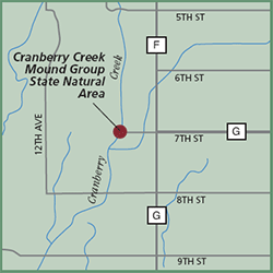
Directions: From Necedah, go north 10 miles on Cty G to its junction with Cty F and 7th Street. Park in the southwest corner of the intersection and walk west along 7th Street into the site. The best mounds are located east of Cranberry Creek, north of the drainage ditch and south of 7th Street. Gazetteer: Page 51, C-8 (prior to 10th edition). | Page 68, D-3 (10th edition). Phone: 608/339-3385 (Friendship WDNR). Web site: WDNR Cranberry Creek Mound Group State Natural Area Signature species: Great Crested Flycatcher and Chipping Sparrow. Rare species: Red-shouldered
Hawk and Merlin. Parking: Parking along road. Nearest food & lodging: Necedah. |